
• हिन्दीEnglishमराठीবাংলাதமிழ்മലയാളംગુજરાતીతెలుగుಕನ್ನಡଓଡ଼ିଶାZ BharatPHHBusinessWION
  • facebookyoutubetwitterwhatsapp
Zee News Odia
  • ଖବର
  • ଭିଡିଓ
  • ଫୋଟୋ
  • ଲାଇଭ୍ ବ୍ଲଗ୍
  • ସହର

Add Zee Business As A Preferred Source
App
  • ଲାଇଭ୍ ଟିଭି
  • ଓଡ଼ିଶା
  • ଜାତୀୟ
  • ଆନ୍ତର୍ଜାତୀୟ
  • ମନୋରଞ୍ଜନ
  • କ୍ରୀଡ଼ା
  • ଧର୍ମ
  • ଚାକିରି
  • ଜି ନ୍ୟୁଜ୍ ଓଡ଼ିଶା
  • /ଓଡ଼ିଶା
  • /Cyclone Update: ସାମ୍ଭାବ୍ୟ ବାତ୍ୟା 'ଅର୍ଣ୍ଣବ'କୁ ନେଇ ଆସିଲା ବଡ଼ ଅପଡେଟ୍! ଲ୍ୟାଣ୍ତଫଲ୍ ପରେ ଓଡ଼ିଶାରେ...

Cyclone Update: ସାମ୍ଭାବ୍ୟ ବାତ୍ୟା 'ଅର୍ଣ୍ଣବ'କୁ ନେଇ ଆସିଲା ବଡ଼ ଅପଡେଟ୍! ଲ୍ୟାଣ୍ତଫଲ୍ ପରେ ଓଡ଼ିଶାରେ...

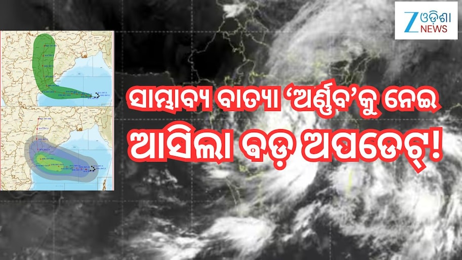
Cyclone Update: ବଙ୍ଗୋପସାଗରର ପୂର୍ବ-ମଧ୍ୟ ଓ ଦକ୍ଷିଣ ପୂର୍ବ ଅଞ୍ଚଳରେ ସୃଷ୍ଟ ଅବପାତ ଶକ୍ତିଶାଳୀ ହୋଇ ଗଭୀର ଅବପାତର ରୂପ ନେଇଛି। ୨୫ ତାରିଖ ସଂନ୍ଧ୍ୟା ୫ଟା ୩୦ ସୁଧା ପୂର୍ବ କେନ୍ଦ୍ରୀୟ ତଥା ତତ ସଲଂଗ୍ନ ଦକ୍ଷିଣ ପୂର୍ବ ବଙ୍ଗୋପସାଗର ରେ ସକ୍ରିୟ ଥିଲା ବେଳେ ପଶ୍ଚିମ ଦିଗକୁ ଘଣ୍ଟାପ୍ରତି ୫ କିମି ବେଗରେ ଗତି କରୁଛି।

Written ByNarmada BeheraEdited ByNarmada Behera
Published: Oct 26, 2026, 07:50 AM IST|Updated: Oct 26, 2026, 10:08 AM IST
joinshare
Cyclone Update: ସାମ୍ଭାବ୍ୟ ବାତ୍ୟା 'ଅର୍ଣ୍ଣବ'କୁ ନେଇ ଆସିଲା ବଡ଼ ଅପଡେଟ୍! ଲ୍ୟାଣ୍ତଫଲ୍ ପରେ ଓଡ଼ିଶାରେ...
Image Credit: ସାମ୍ଭାବ୍ୟ ବାତ୍ୟା 'ଅର୍ଣ୍ଣବ'କୁ ନେଇ ଆସିଲା ବଡ଼ ଅପଡେଟ୍!

About the Author

    Narmada Behera

    Narmada Behera

    ସାମ୍ୱାଦିକତା କ୍ଷେତ୍ରରେ ଦୀର୍ଘ ୧୨ ବର୍ଷର ଅଭିଜ୍ଞତା ରହିଛି । ସମ୍ୱାଦ, ନକ୍ଷତ୍ର ନ୍ୟୁଜ୍, ଇଟିଭି ପରେ ଜୀ ଡିଜିଟାଲରେ କାର୍ଯ୍ୟରତ । ମନୋରଞ୍ଜନଠୁ ଆରମ୍ଭ କରି ପାଣିପାଗ ଏବଂ ଜାତୀୟ ଓ ଅନ୍ତର୍ଜାତୀୟ ଖବର ଲେଖିବାରେ ରୁଚି ରହିଛି ।
    Read More

    ଟ୍ରେଣ୍ଡିଂ

    • ଖବର
    • ଫୋଟୋ
    • ଭିଡିଓ
    ଶେଷ ବଲ୍‌ରେ ପାକିସ୍ତାନକୁ ମାତ୍, U-19 ଏସିଆ କପ୍ ଚାମ୍ପିୟନ୍ ଭାରତ! ୧ ୱିକେଟ୍‌ରେ ରୋମାଞ୍ଚକର ବିଜୟ

    ଶେଷ ବଲ୍‌ରେ ପାକିସ୍ତାନକୁ ମାତ୍, U-19 ଏସିଆ କପ୍ ଚାମ୍ପିୟନ୍ ଭାରତ! ୧ ୱିକେଟ୍‌ରେ ରୋମାଞ୍ଚକର ବିଜୟ

    2

    Top 10 News: ଚୁଟକିରେ ପଢ଼ନ୍ତୁ ଆଜି ଦିନ ତମାମର ୧୦ଟି ଗୁରୁତ୍ୱପୂର୍ଣ୍ଣ ଖବର..

    3

    ଓଡ଼ିଶାକୁ ଆଉ ୧ ଲକ୍ଷ ପିଏମ୍ ଆବାସ, ମୋଟ ମଞ୍ଜୁରୀ ୫ ଲକ୍ଷ; ବଲାଙ୍ଗୀରରୁ ଶୁଭାରମ୍ଭ କଲେ ମୁଖ୍ୟମନ୍ତ୍ରୀ

    4

    Jubilant Ingrevia: ଜୁବିଲାଣ୍ଟ କାରଖାନା ବିରୋଧରେ ସ୍ୱର ଉଠାଇବାରୁ ଧମକ! ZEE MEDIA ରିପୋର୍ଟ ପରେ ହଇଚଇ

    5

    ଓଡ଼ିଶା ହାଇକୋର୍ଟରେ ବିଚାରପତି ସଙ୍କଟ! ୩୩ ପଦରୁ ୨୦ ଖାଲି, କେନ୍ଦ୍ରକୁ ଚିଠି ଲେଖିଲେ ସସ୍ମିତ

    logo
    • contact us
    • privacy policy
    • legal
    • investor info
    • advertise with us
    © 1998-2026 Indiadotcom Digital Private Limited, All Rights Reserved.

    Cyclone Update: ବଙ୍ଗୋପସାଗରର ପୂର୍ବ-ମଧ୍ୟ ଓ ଦକ୍ଷିଣ ପୂର୍ବ ଅଞ୍ଚଳରେ ସୃଷ୍ଟ ଅବପାତ ଶକ୍ତିଶାଳୀ ହୋଇ ଗଭୀର ଅବପାତର ରୂପ ନେଇଛି। ୨୫ ତାରିଖ ସଂନ୍ଧ୍ୟା ୫ଟା ୩୦ ସୁଧା  ପୂର୍ବ କେନ୍ଦ୍ରୀୟ  ତଥା ତତ ସଲଂଗ୍ନ ଦକ୍ଷିଣ ପୂର୍ବ ବଙ୍ଗୋପସାଗର ରେ  ସକ୍ରିୟ ଥିଲା ବେଳେ  ପଶ୍ଚିମ ଦିଗକୁ  ଘଣ୍ଟାପ୍ରତି ୫ କିମି ବେଗରେ ଗତି କରୁଛି।  ଏହା ଆଣ୍ତାମାନ୍ ର ଶ୍ରୀବିଜୟ  ପରମଠାରୁ  ପ୍ରାୟ ୪୫୦ କିମି ଉତ୍ତର -ଉତ୍ତର ପଶ୍ଚିମ ବିଖାଶାପାଟଣା ଠାରୁ  ୮୨୦ କିମି ପୂର୍ବ  ଦକ୍ଷିଣ ପୂର୍ବ, କାକିନାଡା ଠାରୁ  ୯୧୦ କିମି ମଛଲିପଟ୍ଟନମ୍  ଠାରୁ ୧୦୧୦ କିମି  ଓ ବାପତଲା ଠାରୁ ୧୦୮୦ କିମି ଦୂରରେ ରହିଛି।

    ଏହା ପଶ୍ଚିମ ଦିଗ ଆଡ଼କୁ ବଢି(ସୋମବାର) ଆଜି ସକାଳ ସୁଦ୍ଧା ଘୂର୍ଣ୍ଣିଝଡ଼ର ରୂପ ନେବ। ପରେ ଏହା ଉତ୍ତର-ପଶ୍ଚିମ ଦିଗରେ  ଗତି କରି ପଶ୍ଚିମ କେନ୍ଦ୍ରୀୟ ବଙ୍ଗୋପସାଗର ଅଞ୍ଚଳରେ  ମଙ୍ଗଳବାର ସକାଳେ ଭୀଷଣ ବାତ୍ୟା ରୂପ ନେବ। ମଙ୍ଗଳବାର ଦିନ ଏହା ଅଧିକ ଘନୀଭୂତ ହେବ।  ବୁଧବାର ସକାଳ ସୁଧା  ବା ୨୮ ତାରିଖ ସୁଧା  ଏହା ଅତି ଭୀଷଣ ବାତ୍ୟାରେ ରୂପାନ୍ତରିତ ହୋଇ  ଆନ୍ଧ୍ର ଉପକୂଳରେ ପହଞ୍ଚିବ।


    Subject: Deep Depression intensified into Cyclonic Storm “Arnab” [Pronunciation : Ornab] over Eastcentral and adjoining Westcentral Bay of Bengal [Cyclone Warning for Andhra Pradesh and adjoining South Odisha coasts—Red Message] The Deep Depression over Eastcentral and adjoining Southeast Bay of Bengal moved nearly westwards with a speed of 15 kmph during last 6 hours, intensified into cyclonic storm ““Arnab” [Pronunciation :Ornab]” and lay centered at 0530 hrs IST of today, the 26th October, 2026 over Eastcentral and adjoining Westcentral Bay of Bengal near latitude 15.4°N and longitude 88.9°E, about 590 km northwest of Sri Vijaya Puram (#Andaman Islands), 610 km southeast of Gopalpur (Odisha), 650 km east-southeast of Vishakhapatnam (Andhra Pradesh), 730 km east-southeast of Kakinada (Andhra Pradesh), 830 km east of Machilipatnam (Andhra Pradesh) and 910 km east of Bapatla (Andhra Pradesh). It is very likely to move west-northwestwards and intensify further into a severe cyclonic storm over westcentral Bay of Bengal by midnight of today, the 26th October and into a very severe cyclonic storm over the same region on 27th October. Thereafter, it is very likely to move northwestwards and cross Andhra Pradesh & Yanam coasts between Bapatla and Visakhapatnam as a very severe cyclonic storm with the maximum sustained wind speed of 115-125 kmph gusting to 140 kmph by forenoon of 28th October, 2026.

    — India Meteorological Department (@Indiametdept) October 26, 2026


    The #Deep #Depression over Eastcentral and adjoining Southeast #Bay of #Bengal moved west-northwestwards with speed of 15 kmph during past 6 hours and lay centered at 2330 hours IST of yesterday, the 25th October, 2026 over the same region, near Latitude 15.3°N and Longitude 89.7°E, about 520 km north-northwest of Sri Vijaya Puram (#Andaman Islands), 730 km east-southeast of #Vishakhapatnam (#Andhra_Pradesh), 820 km east-southeast of #Kakinada (Andhra Pradesh), 920 km east-Southeast of #Machilipatnam (Andhra Pradesh) and 990 km east of #Bapatla (Andhra Pradesh). It is very likely to move nearly westwards, and intensify further into a cyclonic storm over Eastcentral & adjoining Southeast Bay of #Bengal by 26th October early morning. Then it is very likely to move west-northwestwards and intensify into a #severe #cyclonic #storm over westcentral Bay of Bengal by 27th #October, morning. Thereafter, it is very likely to move northwestwards, intensify further into a very severe cyclonic storm and reach Westcentral #Bay_of_Bengal near Andhra Pradesh coast around morning of 28th October, 2026. It is very likely to cross Andhra Pradesh & Yanam coasts between Bapatla and Visakhapatnam as a #very #severe #cyclonic #storm with the maximum sustained wind speed of 115-125 kmph gusting to 140 kmph by forenoon of 28th October, 2026.

    — India Meteorological Department (@Indiametdept) October 25, 2026


    ପାଣିପାଗର ବର୍ତ୍ତମାନ ସ୍ଥିତି #Odisha #lowpressure https://t.co/SgWCG96hgJ

    — Meteorological Centre, Bhubaneswar (@mcbbsr) October 25, 2026


    ବାପତଲା ଓ ବିଶାଖାପାଟଣା  ମଧ୍ୟରେ  ୟାନାମ୍  ଉପକୂଳ ଅଞ୍ଚଳେ  ଏହି ସମୟରେ ପବନର ବେଗ ଘଣ୍ଟାପ୍ରତି ୧୧୫ ରୁ ୧୨୫ କିମି ଭିତରେ ରହିବା ସହ ଅତି ପ୍ରବଳ ବର୍ଷା ସହ ବାତ୍ୟା ଅର୍ଣ୍ଣବ ୨୮ ତାରିଖ ଅପରାହ୍ନ ବେଳକୁ ସ୍ଥଳଭାଗ ଛୁଇଁବ ବୋଲି ଆଇଏମଡି଼ ପକ୍ଷରୁ କୁହାଯାଇଛି।  ଉପକୂଳ ଅଞ୍ଚଳରେ ଏନେଇ ମତ୍ସଜୀବୀଙ୍କୁ ସମୁଦ୍ର ମଧ୍ୟକୁ ନଯିବାକୁ ନିଷେଧ କରାଯାଇଛି।  କୋଣାର୍କ ନିକଟସ୍ତ ଚନ୍ଦ୍ରଭାଗା ବିଚ୍ ରେ ପର୍ଯ୍ୟଟକଙ୍କୁ ନିଷେଧ କରାଯାଇଛି। ଆଗାମୀ ୩ ଦିନ ମଧ୍ୟରେ  ବାତ୍ୟାର ଗତିପଥ , ତ୍ରୀବ୍ରତାରେ ପରିବର୍ତ୍ତନ  ଆସିବା ସମ୍ଭାବନା  ଥିବାରୁ ପରାମର୍ଶ ଦିଆଯାଇଛି। ସରକାରୀ ନିର୍ଦ୍ଦେଶ ଅନୁସରଣ କରିବା ସହ  ଆତ୍ୟବଶ୍ୟକ ସତର୍କତା ଗ୍ରହଣ କରିବାକୁ ପାଣିପାଗ ବିଜ୍ଞାନୀ କହିଛନ୍ତି।

    ସେପଟେ, ବାତ୍ୟା ଅର୍ଣ୍ଣବର ପ୍ରଭାବରେ ଓଡ଼ିଶାରେ ୨୭ ଓ  ୨୮ ତାରିଖରେ ପ୍ରବଳ ବର୍ଷା ହେବ। ଏବଂ ଆଉ ଏକ ପାଣିପାଗ ମଡେଲ୍ ଦର୍ଶାଇଛି ଯେ, ବାତ୍ୟାଟି ଆନ୍ଧ୍ର ଛୁଇଁଲା ବେଳକୁ ଆଉ ଏକ ଲଘୁଚାପ ଓଡି଼ଶା ଭିତରକୁ ପଶିବ।  ଗୋପାଳପୁରରୁ ପାରାଦୀପ ଭିତରେ  ଏହି ଲଘୁଚାପ ପ୍ରଭାବରେ  ସାରା ରାଜ୍ୟରେ ବର୍ଷା ହେବ। ଓଡ଼ିଶାକୁ ସାମ୍ଭାବ୍ୟ ବାତ୍ୟା ସିଧାସଳଖ ମାଡ଼ ହେବନି ବୋଲି କହିଛି ଆଇଏମଡି। କିନ୍ତୁ ବାତ୍ୟାରେ ପ୍ରଭାବରେ ୨୭ ତାରିଖରୁ ଘଣ୍ଟାପ୍ରତି ପବନ ୪୦ ରୁ ୫୦ କିମି ଭିତରେ ରହିବ।

    ୨୮ରେ ଗଜପତି, କୋରାପୁଟ୍, ରାୟଗଡା, ମାଲକାନଗିରି, ନବରଙ୍ଗପୁର, ଜିଲ୍ଲା ଉପର ଦେଇ ଯିବ। ସେବେ  ଘଣ୍ଟା ପ୍ରତି ୬୦ ରୁ ୭୦ କିମି ବେଗରେ ପବନ ବହିବ।  ଆଜିଠାରୁ ୨୮ ତାରିଖ ଯାଏଁ  ଦକ୍ଷିଣ ଓଡ଼ିଶା ସମେତ  ନୂଆପଡା, କନ୍ଧମାଳ, କଳାହାଣ୍ତି, ରେ ପ୍ରବଳରୁ ଅତି ପ୍ରବଳ ବର୍ଷା ହେବ। ଏବଂ ୨୯ ରେ ପଶ୍ଚିମ ଓଡି଼ଶାରେ  ପ୍ରବଳରୁ ଅତି ପ୍ରବଳ ବର୍ଷ ଆଶାଙ୍କା ରହିଛି।ଏବଂ ୩୧ ଓ ୩୧ ରେ ବାଲେଶ୍ବର, ମୟୂରଭଞ୍ଜ, କେନ୍ଦୁଝର, ଭଦ୍ରକରେ ହାଲୁକାରୁ ମଧ୍ୟମ ଧରଣର ବର୍ଷା ହୋଇପାରେ। ବିଶେଷକରି, ରାୟଗଡା, କୋରାପୁଟ୍, ମାଲକାନଗିରି, ଗଜପତି ଓ ଗଞ୍ଜାମକୁ ରେଡ୍ ଆଲର୍ଟ ଜାରି କରାଯାଇଛି। ତୁହାକୁ ତୁହା ବର୍ଷା ଯୋଗୁଁ ପାହାଡ଼ିଆ ଅଞ୍ଚଳରେ ଭୂସ୍ଖଳନ ହୋଇପାରେ।  
     

    Add Zee News as a Preferred Source
    TAGS:
    Odia News