• हिन्दीEnglishमराठीবাংলাதமிழ்മലയാളംગુજરાતીతెలుగుಕನ್ನಡଓଡ଼ିଶାZ BharatPHHBusinessWION
  • facebookyoutubetwitterwhatsapp
Zee News Odia
  • ଖବର
  • ଭିଡିଓ
  • ଫୋଟୋ
  • ଲାଇଭ୍ ବ୍ଲଗ୍
  • ସହର

Add Zee Business As A Preferred Source
App
  • ଲାଇଭ୍ ଟିଭି
  • ଓଡ଼ିଶା
  • ଜାତୀୟ
  • ଆନ୍ତର୍ଜାତୀୟ
  • ମନୋରଞ୍ଜନ
  • କ୍ରୀଡ଼ା
  • ଧର୍ମ
  • ଚାକିରି
  • ଜି ନ୍ୟୁଜ୍ ଓଡ଼ିଶା
  • /ଓଡ଼ିଶା
  • /Cyclonic Storm: ଘନୀଭୂତ ହେଉଛି ବାତ୍ୟା, ୧୪୫ କି.ମି ବେଗରେ ବହିବ ପବନ! ଏହି ସବୁ ସ୍ଥାନ ପାଇଁ ଆଲର୍ଟ ଜାରି...

Cyclonic Storm: ଘନୀଭୂତ ହେଉଛି ବାତ୍ୟା, ୧୪୫ କି.ମି ବେଗରେ ବହିବ ପବନ! ଏହି ସବୁ ସ୍ଥାନ ପାଇଁ ଆଲର୍ଟ ଜାରି...

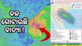
IMDର ସୂଚନା ଅନୁସାରେ, ନଭେମ୍ବର ୧୬ ତାରିଖ ସକାଳ ୧୧ଟା ୩୦ ସୁଦ୍ଧା ଗଭୀର ଅବପାତଟି ଦକ୍ଷିଣ-ପୂର୍ବ ଓ ସଂଲଗ୍ନ ଦକ୍ଷିଣ-ପଶ୍ଚିମ ବଙ୍ଗୋପସାଗରରେ ୧୧.୭ ଡିଗ୍ରୀ ଉତ୍ତର ଅକ୍ଷାଂଶ ଓ ୮୬.୦ ଡିଗ୍ରୀ ପୂର୍ବ ଦ୍ରାଘିମା ନିକଟରେ କେନ୍ଦ୍ରୀଭୂତ ରହିଥିଲା। ଗତ ୬ ଘଣ୍ଟାରେ ଏହା ଘଣ୍ଟାପ୍ରତି ୧୭ କିଲୋମିଟର ବେଗରେ ଉତ୍ତର-ଉତ୍ତର ପଶ୍ଚିମ ଦିଗକୁ ଗତି କରିଛି।

Written ByPriyambada RanaEdited ByPriyambada Rana
Published: Nov 16, 2026, 17:18 IST|Updated: Nov 16, 2026, 17:28 IST

joinshare
Cyclonic Storm: ଘନୀଭୂତ ହେଉଛି ବାତ୍ୟା, ୧୪୫ କି.ମି ବେଗରେ ବହିବ ପବନ! ଏହି ସବୁ ସ୍ଥାନ ପାଇଁ ଆଲର୍ଟ ଜାରି...
Image Credit: AI

About the Author

    Priyambada Rana

    Priyambada Rana

    I am Priyambada Rana, a journalist and content professional with experience in digital media and journalism. I previously worked with Krishi Jagran, where I gained experience in agricultural journalism and content creation. Currently, I am working as a Sub-Editor at India.com, focusing on content writing, editing, research, and producing engaging digital content for readers.
    Read More

    ଟ୍ରେଣ୍ଡିଂ

    • ଖବର
    • ଫୋଟୋ
    • ଭିଡିଓ
    Cyclone Alert: ଗତ ୯ ଘଣ୍ଟା ଧରି ପ୍ରାୟ ସମାନ ସ୍ଥାନରେ ରହିଛି ବାତ୍ୟା

    Cyclone Alert: ଗତ ୯ ଘଣ୍ଟା ଧରି ପ୍ରାୟ ସମାନ ସ୍ଥାନରେ ରହିଛି ବାତ୍ୟା

    2

    Today Horoscope: ଆଜି ଆପଣଙ୍କର ଭାଗ୍ୟ କେମିତି ରହିବ ? ପଢ଼ନ୍ତୁ ରାଶିଫଳ

    3

    Amitabh Bachchan Threat: ଅମିତାଭ ବଚ୍ଚନ ଓ ଅଭିଷେକଙ୍କୁ ଗ୍ୟାଙ୍ଗଷ୍ଟର ଗୋଲ୍ଡି ଢିଲ୍ଲୋନଙ୍କ ଧମକ! ‘୨୦୦ ଲୋକ ପ୍ରସ୍ତୁତ’

    4

    Top 10 News: ଚୁଟକିରେ ପଢ଼ନ୍ତୁ ଆଜି ଦିନ ତମାମର ୧୦ଟି ଗୁରୁତ୍ୱପୂର୍ଣ୍ଣ ଖବର..

    5

    Cyclone Akvan: ଭୀଷଣ ରୂପ ନେଲା ଗଭୀର ଅବପାତ, ଆନ୍ଧ୍ର ଉପକୂଳ ମୁହାଁ ବାତ୍ୟା ‘AKVAN’

    logo
    • contact us
    • privacy policy
    • legal
    • investor info
    • advertise with us
    © 1998-2026 Indiadotcom Digital Private Limited, All Rights Reserved.

    Severe Cyclonic Storm: ବଙ୍ଗୋପସାଗରରେ ସୃଷ୍ଟ ଗଭୀର ଅବପାତ ଧୀରେ ଧୀରେ ଅଧିକ ଘନୀଭୂତ ହେବାରେ ଲାଗିଛି। ଏହା ଆଗାମୀ ଦିନରେ ଭୀଷଣ ବାତ୍ୟାର ରୂପ ନେଇ ଆନ୍ଧ୍ରପ୍ରଦେଶ ଉପକୂଳ ଆଡ଼କୁ ମୁହାଁଇବାର ସମ୍ଭାବନା ରହିଛି। ଭାରତୀୟ ପାଣିପାଗ ବିଭାଗ (IMD)ର ଆକଳନ ଅନୁଯାୟୀ, ନଭେମ୍ବର ୨୦ ତାରିଖ ମଧ୍ୟାହ୍ନ ସୁଦ୍ଧା ନେଲୋର ଓ ଟୁନି ମଧ୍ୟରେ ଏହି ବାତ୍ୟା ସ୍ଥଳଭାଗ ଅତିକ୍ରମ କରିପାରେ।

    IMDର ସୂଚନା ଅନୁସାରେ, ନଭେମ୍ବର ୧୬ ତାରିଖ ସକାଳ ୧୧ଟା ୩୦ ସୁଦ୍ଧା ଗଭୀର ଅବପାତଟି ଦକ୍ଷିଣ-ପୂର୍ବ ଓ ସଂଲଗ୍ନ ଦକ୍ଷିଣ-ପଶ୍ଚିମ ବଙ୍ଗୋପସାଗରରେ ୧୧.୭ ଡିଗ୍ରୀ ଉତ୍ତର ଅକ୍ଷାଂଶ ଓ ୮୬.୦ ଡିଗ୍ରୀ ପୂର୍ବ ଦ୍ରାଘିମା ନିକଟରେ କେନ୍ଦ୍ରୀଭୂତ ରହିଥିଲା। ଗତ ୬ ଘଣ୍ଟାରେ ଏହା ଘଣ୍ଟାପ୍ରତି ୧୭ କିଲୋମିଟର ବେଗରେ ଉତ୍ତର-ଉତ୍ତର ପଶ୍ଚିମ ଦିଗକୁ ଗତି କରିଛି।

    The Deep Depression over Southeast & adjoining Southwest Bay of Bengal moved north-northwestwards with the speed of 17 kmph during past 06 hours and lay centered at 1130 hours IST of today, the 16th November, 2026 over the same region, near Latitude 11.7°N and Longitude 86.0°E, about 620 km northeast of Trincomalee (Sri Lanka), 730km west of Sri Vijaya Puram (Andaman & Nicobar Islands), 650 km east-southeast of Chennai (Tamil Nadu), 730 km south-southeast of Visakhapatnam (Andhra Pradesh) and 850 km south of Gopalpur (Odisha). It is very likely to continue to move north-northwestwards, intensify further into a Cyclonic Storm over the central parts of south & adjoining westcentral Bay of Bengal in the evening of today, the 16th November and into a Severe Cyclonic Storm over westcentral Bay of Bengal in the evening of 17th November, 2026. Thereafter, it is likely to intensify further and move west-northwestwards and cross Andhra Pradesh & Yanam coasts between Nellore and Tuni, around noon of 20th November, 2026 as a very severe cyclonic storm with the maximum sustained wind speed of 120-130 kmph gusting to 145 kmph.

    — India Meteorological Department (@Indiametdept) November 16, 2026

    ୧୭ରେ ଭୀଷଣ ବାତ୍ୟାର ରୂପ ନେବା ସମ୍ଭାବନା:
    ପାଣିପାଗ ବିଭାଗର ଆକଳନ ଅନୁଯାୟୀ, ନଭେମ୍ବର ୧୬ ତାରିଖ ସନ୍ଧ୍ୟା ସୁଦ୍ଧା ଏହି ଗଭୀର ଅବପାତ ସାମୁଦ୍ରିକ ଝଡ଼ ବା Cyclonic Stormରେ ପରିଣତ ହୋଇପାରେ। ପରବର୍ତ୍ତୀ ସମୟରେ ଏହା ଅଧିକ ଶକ୍ତିଶାଳୀ ହୋଇ ନଭେମ୍ବର ୧୭ ତାରିଖ ସନ୍ଧ୍ୟା ସୁଦ୍ଧା Severe Cyclonic Storm ବା ଭୀଷଣ ବାତ୍ୟାର ରୂପ ନେବାର ସମ୍ଭାବନା ରହିଛି। ଏହାପରେ ବାତ୍ୟାଟି ଉତ୍ତର-ପଶ୍ଚିମ ଦିଗକୁ ଗତି କରି ଆନ୍ଧ୍ରପ୍ରଦେଶ ଉପକୂଳ ଆଡ଼କୁ ଅଗ୍ରସର ହୋଇପାରେ।

    Cyclone Alert Over Bay of Bengal! The Deep Depression over the southeast and adjoining southwest Bay of Bengal is very likely to intensify into a Cyclonic Storm by the evening of 16th November, followed by a Severe Cyclonic Storm by 17th November 2026. The system is likely to intensify further and move northwestwards, reaching the westcentral Bay of Bengal near the Andhra Pradesh coast as a Very Severe Cyclonic Storm around the night of 19th November 2026. Stay tuned for the latest weather updates and follow IMD advisories. #IMD #CycloneAlert #BayOfBengal #CyclonicStorm #AndhraPradesh #WeatherUpdate #IMDWeather @moesgoi @airnewsalerts @DDNational @ndmaindia @ICRER_MHA

    — India Meteorological Department (@Indiametdept) November 16, 2026

    ସ୍ଥଳଭାଗ ଛୁଇଁବା ବେଳେ ପବନର ବେଗ ୧୩୦ କି.ମି!
    IMDର ପୂର୍ବାନୁମାନ ଅନୁଯାୟୀ, ନଭେମ୍ବର ୨୦ ତାରିଖ ମଧ୍ୟାହ୍ନ ସମୟରେ ନେଲୋର ଓ ଟୁନି ମଧ୍ୟବର୍ତ୍ତୀ ଅଞ୍ଚଳରେ ଏହି ବାତ୍ୟା ସ୍ଥଳଭାଗ ଅତିକ୍ରମ କରିପାରେ। ସେହି ସମୟରେ ସର୍ବାଧିକ ସ୍ଥାୟୀ ପବନର ବେଗ ଘଣ୍ଟାପ୍ରତି ୧୨୦ରୁ ୧୩୦ କିଲୋମିଟର ରହିବା ସହ ଝଟକା ପବନର ବେଗ ୧୪୫ କିଲୋମିଟର ପର୍ଯ୍ୟନ୍ତ ରହିବାର ସମ୍ଭାବନା ରହିଛି।

    ଓଡ଼ିଶାରେ ୧୯ ଓ ୨୦ରେ ପ୍ରବଳ ବର୍ଷା ଆଶଙ୍କା:
    ବାତ୍ୟାର ପ୍ରଭାବ ଓଡ଼ିଶାରେ ମଧ୍ୟ ଅନୁଭୂତ ହୋଇପାରେ। IMD ଡିଜି ମୃତ୍ୟୁଞ୍ଜୟ ମହାପାତ୍ରଙ୍କ ସୂଚନା ଅନୁଯାୟୀ, ନଭେମ୍ବର ୧୮ ତାରିଖରେ ରାଜ୍ୟର କିଛି ଅଞ୍ଚଳରେ ସ୍ୱଳ୍ପରୁ ମଧ୍ୟମ ଧରଣର ବର୍ଷା ହୋଇପାରେ।

    ତେବେ ୧୯ ଓ ୨୦ ତାରିଖରେ ବର୍ଷାର ପରିମାଣ ବଢ଼ିବା ସହ କିଛି ସ୍ଥାନରେ ପ୍ରବଳ ବର୍ଷା ହେବାର ଆଶଙ୍କା ରହିଛି। ଦକ୍ଷିଣ ଓଡ଼ିଶା ସମେତ ବାଲେଶ୍ୱର, ଭଦ୍ରକ ଓ ମୟୂରଭଞ୍ଜ ଜିଲ୍ଲାରେ ମଧ୍ୟ ବର୍ଷା ହୋଇପାରେ। ତେବେ ଅତ୍ୟନ୍ତ ପ୍ରବଳ ବର୍ଷା ହେବାର ସେପରି ସମ୍ଭାବନା ନଥିବା ସୂଚନା ଦିଆଯାଇଛି।

    Current Synoptic Situation #Odisha https://t.co/KBdgLkKD49

    — Meteorological Centre, Bhubaneswar (@mcbbsr) November 16, 2026

    ଏଲ୍‌ନିନୋ ବର୍ଷରେ ବଙ୍ଗୋପସାଗରରେ ବାତ୍ୟା ସମ୍ଭାବନା:
    IMD ଡିଜିଙ୍କ କହିବା ଅନୁଯାୟୀ, ଅକ୍ଟୋବର ଓ ନଭେମ୍ବର ମାସରେ ବଙ୍ଗୋପସାଗରରେ ସାଧାରଣତଃ ପ୍ରାୟ ୩ଟି ବାତ୍ୟା ସୃଷ୍ଟି ହୋଇଥାଏ। ଚଳିତ ଥର ମଧ୍ୟ ତିନୋଟି ବାତ୍ୟା ସୃଷ୍ଟି ହେବାର ପ୍ରକ୍ରିୟାରେ ଏହା ତୃତୀୟ ବାତ୍ୟା ହେବାକୁ ଯାଉଛି। ଏଲ୍‌ନିନୋ ବର୍ଷଗୁଡ଼ିକରେ ଦକ୍ଷିଣ ବଙ୍ଗୋପସାଗରରେ ବାତ୍ୟା ସୃଷ୍ଟି ହେବା ସହ ଏହା ଆନ୍ଧ୍ରପ୍ରଦେଶ ଓ ତାମିଲନାଡୁ ଉପକୂଳ ଆଡ଼କୁ ମୁହାଁଇଥାଏ।

    ତେବେ ବାତ୍ୟାର ଗତିପଥ ଓ ତୀବ୍ରତାରେ ପରିବର୍ତ୍ତନ ହୋଇପାରେ। ତେଣୁ ଆଗାମୀ ପାଣିପାଗ ବୁଲେଟିନ୍ ଉପରେ ନଜର ରଖିବା ସହ IMDର ସରକାରୀ ସତର୍କ ସୂଚନା ଅନୁସରଣ କରିବାକୁ ପରାମର୍ଶ।

    Add Zee News as a Preferred Source
    TAGS:
    Weather Update