• हिन्दीEnglishमराठीবাংলাதமிழ்മലയാളംગુજરાતીతెలుగుಕನ್ನಡଓଡ଼ିଶାZ BharatPHHBusinessWION
  • facebookyoutubetwitterwhatsapp
Zee News Odia
  • ଖବର
  • ଭିଡିଓ
  • ଫୋଟୋ
  • ଲାଇଭ୍ ବ୍ଲଗ୍
  • ସହର

Add Zee Business As A Preferred Source
App
  • ଲାଇଭ୍ ଟିଭି
  • ଓଡ଼ିଶା
  • ଜାତୀୟ
  • ଆନ୍ତର୍ଜାତୀୟ
  • ମନୋରଞ୍ଜନ
  • କ୍ରୀଡ଼ା
  • ଧର୍ମ
  • ଚାକିରି
  • ଜି ନ୍ୟୁଜ୍ ଓଡ଼ିଶା
  • /ଧର୍ମ
  • /Cyclone Alert: ଧୀରେ ଧୀରେ ଉତ୍ତର ଦିଗକୁ ଗତି କରୁଛି ବାତ୍ୟା 'ଆକଭାନ୍'

Cyclone Alert: ଧୀରେ ଧୀରେ ଉତ୍ତର ଦିଗକୁ ଗତି କରୁଛି ବାତ୍ୟା 'ଆକଭାନ୍'

ଧୀରେ ଧୀରେ ଉତ୍ତର-ଉତ୍ତରପଶ୍ଚିମ ଦିଗକୁ ଗତି କରି ଆଜି, ୧୮ ନଭେମ୍ବର ସକାଳ ସୁଦ୍ଧା ପଶ୍ଚିମ-କେନ୍ଦ୍ରୀୟ ବଙ୍ଗୋପସାଗର ଉପରେ ଅଧିକ ଘନୀଭୂତ ହୋଇ ଏକ ଭୀଷଣ ସାମୁଦ୍ରିକ ଝଡ଼ ରୂପ ନେବାର ଯଥେଷ୍ଟ ସମ୍ଭାବନା ରହିଛି।

Written BySoubhagya Ranjan MishraEdited BySoubhagya Ranjan Mishra
Published: Nov 18, 2026, 06:48 IST|Updated: Nov 18, 2026, 07:03 IST
joinshare
Cyclone Alert: ଧୀରେ ଧୀରେ ଉତ୍ତର ଦିଗକୁ ଗତି କରୁଛି ବାତ୍ୟା 'ଆକଭାନ୍'
Image Credit: Cyclone Update

About the Author

Soubhagya Ranjan Mishra

Soubhagya Ranjan Mishra

Soubhagya Ranjan Mishra is a senior and well-known journalist. He has served in senior positions at prominent media houses like Zee Media and Network18. Throughout his career, he has achieved versatile success ranging from TV promos and programming to digital journalism. Additionally, he has also worked extensively as a freelancer. For over two years, he contributed as an AI Content Reviewer at IIT Patna. He brings more than 11 years of rich experience working exclusively in national media. After completing his Postgraduate degree in journalism from SSOMAC, he has continuously advanced his career in the media industry. In the early stages of his career, he developed a keen interest in entertainment journalism, fostering excellent professional relationships with numerous artists in the Odisha entertainment industry.
Read More

ଟ୍ରେଣ୍ଡିଂ

  • ଖବର
  • ଫୋଟୋ
  • ଭିଡିଓ
Cyclone Update: ଆନ୍ଧ୍ର ନୁହେଁ ଓଡ଼ିଶା ମୁହାଁ 'ବାତ୍ୟା'! ସ୍ପଷ୍ଟ କଲେ IMD ଡିଜି

Cyclone Update: ଆନ୍ଧ୍ର ନୁହେଁ ଓଡ଼ିଶା ମୁହାଁ 'ବାତ୍ୟା'! ସ୍ପଷ୍ଟ କଲେ IMD ଡିଜି

2

Odisha Assembly: ବିଧାନସଭା ଆରମ୍ଭରୁ ବିରୋଧୀଙ୍କ ହଟ୍ଟଗୋଳ, ୪ଟା ଯାଏଁ ମୁଲତବି

3

ଦୁର୍ଘଟଣାରେ ଜୀବନହାନି ପାଇଁ ଦାୟୀ ଅଧିକାରୀଙ୍କ ବିରୋଧରେ କଠୋର କାର୍ଯ୍ୟାନୁଷ୍ଠାନ ଦାବି

4

Top 10 News: ଆଜିଠାରୁ ବିଧାନସଭା ଶୀତକାଳୀନ ଅଧିବେଶନ, ବର୍ଷା ନେଇ ଅରେଞ୍ଜ ୱାର୍ଣ୍ଣିଂ ଓ ଅନ୍ୟ ଖବର

5

ବକେୟା ପାଉଣା ପାଇଁ ରାସ୍ତାରେ ହାଇଡ୍ରାମା, ଅପେରା ଗାଡ଼ି ଅଟକାଇଲେ କଳାକାର!

logo
  • contact us
  • privacy policy
  • legal
  • investor info
  • advertise with us
© 1998-2026 Indiadotcom Digital Private Limited, All Rights Reserved.

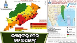
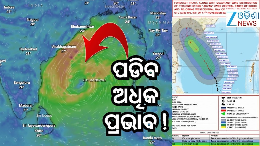
Weather Update: ଦକ୍ଷିଣ ବଙ୍ଗୋପସାଗରର କେନ୍ଦ୍ରୀୟ ଅଂଶ ଏବଂ ଏହାର ପାର୍ଶ୍ୱବର୍ତ୍ତୀ ପଶ୍ଚିମ-କେନ୍ଦ୍ରୀୟ ବଙ୍ଗୋପସାଗର ଉପରେ ସୃଷ୍ଟି ହୋଇଥିବା ସାମୁଦ୍ରିକ ଝଡ଼ “ଆକଭାନ୍” ଗତ ୦୬ ଘଣ୍ଟା ମଧ୍ୟରେ ଘଣ୍ଟାପ୍ରତି ୦୩ କିଲୋମିଟର ବେଗରେ ଧୀରେ ଧୀରେ ଉତ୍ତର ଦିଗକୁ ଗତି କରିଛି। ଏହା ଗତକାଲି, ୧୭ ନଭେମ୍ବର ୨୦୨୬ ରାତି ୨୩:୩୦ ଘଟିକା (IST) ସମୟରେ ସେହି ଅଞ୍ଚଳରେ, ୧୨.୫° ଉତ୍ତର ଅକ୍ଷାଂଶ ଏବଂ ୮୫.୬° ପୂର୍ବ ଦ୍ରାଘିମା ନିକଟରେ କେନ୍ଦ୍ରୀଭୂତ ରହିଥିଲା। ଏହା ଚେନ୍ନାଇ (ତାମିଲନାଡୁ) ଠାରୁ ପ୍ରାୟ ୫୯୦ କିଲୋମିଟର ପୂର୍ବରେ, ତ୍ରିଙ୍କୋମାଲି (ଶ୍ରୀଲଙ୍କା) ଠାରୁ ୬୪୦ କିଲୋମିଟର ଉତ୍ତର-ପୂର୍ବରେ, ମଛଲିପଟ୍ଟନମ୍ (ଆନ୍ଧ୍ରପ୍ରଦେଶ) ଠାରୁ ୬୩୦ କିଲୋମିଟର ଦକ୍ଷିଣ-ପୂର୍ବରେ, ବିଶାଖାପାଟଣା (ଆନ୍ଧ୍ରପ୍ରଦେଶ) ଠାରୁ ୬୩୦ କିଲୋମିଟର ଦକ୍ଷିଣ-ଦକ୍ଷିଣପୂର୍ବରେ ଏବଂ ଗୋପାଳପୁର (ଓଡ଼ିଶା) ଠାରୁ ୭୬୦ କିଲୋମିଟର ଦକ୍ଷିଣରେ ଅବସ୍ଥିତ ରହିଛି।

The Cyclonic Storm “Akvan” [Pronunciation: Akvan] over central parts of South and adjoining Westcentral Bay of Bengal moved slowly northwards with the speed of 03 kmph during past 06 hours and lay centered at 2330 hours IST of yesterday, the 17th November, 2026 over the same region, near Latitude 12.5°N and Longitude 85.6°E, about 590 km east of Chennai (Tamil Nadu), 640 km northeast of Trincomalee (Sri Lanka), 630 km southeast of Machilipatnam (Andhra Pradesh), 630 km south-southeast of Visakhapatnam (Andhra Pradesh) and 760 km south of Gopalpur (Odisha). It is very likely to move slowly north-northwestwards and intensify further into a Severe Cyclonic Storm over westcentral Bay of Bengal around morning of today, the 18th November. Thereafter, it is likely to move northwestwards and intensify further into a very severe cyclonic storm around evening of 19th November, 2026. Continuing to move northwestward, it is likely to cross Andhra Pradesh & Yanam coasts between Nellore and Visakhapatnam, around noon of 20th November, 2026 as a very severe cyclonic storm with the maximum sustained wind speed of 120-130 kmph gusting to 145 kmph.

— India Meteorological Department (@Indiametdept) November 17, 2026

ଏହା ଧୀରେ ଧୀରେ ଉତ୍ତର-ଉତ୍ତରପଶ୍ଚିମ ଦିଗକୁ ଗତି କରି ଆଜି, ୧୮ ନଭେମ୍ବର ସକାଳ ସୁଦ୍ଧା ପଶ୍ଚିମ-କେନ୍ଦ୍ରୀୟ ବଙ୍ଗୋପସାଗର ଉପରେ ଅଧିକ ଘନୀଭୂତ ହୋଇ ଏକ ଭୀଷଣ ସାମୁଦ୍ରିକ ଝଡ଼ ରୂପ ନେବାର ଯଥେଷ୍ଟ ସମ୍ଭାବନା ରହିଛି। ଏହାପରେ, ଏହା ଉତ୍ତର-ପଶ୍ଚିମ ଦିଗକୁ ଗତି କରି ୧୯ ନଭେମ୍ବର ୨୦୨୬ ସନ୍ଧ୍ୟା ସୁଦ୍ଧା ଆହୁରି ଘନୀଭୂତ ହୋଇ ଏକ ଅତି ଭୀଷଣ ସାମୁଦ୍ରିକ ଝଡ଼ରେ ପରିଣତ ହେବାର ସମ୍ଭାବନା ଅଛି।

ଉତ୍ତର-ପଶ୍ଚିମ ଦିଗରେ ଏହାର ଗତି ଜାରି ରଖି, ଏହା ୨୦ ନଭେମ୍ବର ୨୦୨୬ ମଧ୍ୟାହ୍ନ ସୁଦ୍ଧା ଏକ ଅତି ଭୀଷଣ ସାମୁଦ୍ରିକ ଝଡ଼ ଭାବେ ନେଲୋର ଏବଂ ବିଶାଖାପାଟଣା ମଧ୍ୟରେ ଆନ୍ଧ୍ରପ୍ରଦେଶ ଏବଂ ୟାନମ୍ ଉପକୂଳ ଅତିକ୍ରମ କରିବାର ସମ୍ଭାବନା ରହିଛି। ଏହି ସମୟରେ ପବନର ସର୍ବାଧିକ ବେଗ ଘଣ୍ଟାପ୍ରତି ୧୨୦ ରୁ ୧୩୦ କିଲୋମିଟର ରହିବା ସହ ଝଟକା ପବନର ବେଗ ଘଣ୍ଟାପ୍ରତି ୧୪୫ କିଲୋମିଟର ପର୍ଯ୍ୟନ୍ତ ଯାଇପାରେ।

୧୮ ନଭେମ୍ବର ସକାଳଠାରୁ ଝଡ଼ବର୍ଷା ସହ ଘଣ୍ଟାପ୍ରତି ୪୦ ରୁ ୫୦ କିଲୋମିଟର ବେଗରେ ପବନ ବହିବା ଆରମ୍ଭ ହେବାର ସମ୍ଭାବନା ରହିଛି ଏବଂ ଝଟକା ପବନର ବେଗ ଘଣ୍ଟାପ୍ରତି ୬୦ କିଲୋମିଟର ପର୍ଯ୍ୟନ୍ତ ଯାଇପାରେ। ୧୯ ନଭେମ୍ବରରୁ ୨୦ ନଭେମ୍ବର ସକାଳ ପର୍ଯ୍ୟନ୍ତ ଓଡ଼ିଶା ଉପକୂଳ ଏବଂ ଏହାର ଆଖପାଖ ସମୁଦ୍ର ଅଞ୍ଚଳରେ ପବନର ବେଗ ବୃଦ୍ଧି ପାଇ ଘଣ୍ଟାପ୍ରତି ୫୦ ରୁ ୬୦ କିଲୋମିଟର ରହିବା ସହ ଝଟକା ପବନର ବେଗ ଘଣ୍ଟାପ୍ରତି ୭୦ କିଲୋମିଟର ପର୍ଯ୍ୟନ୍ତ ହେବାର ସମ୍ଭାବନା ଅଛି।

୧୮ ନଭେମ୍ବରରୁ ୨୦ ନଭେମ୍ବର, ୨୦୨୬ ପର୍ଯ୍ୟନ୍ତ ଓଡ଼ିଶା ଉପକୂଳ ଏବଂ ଏହାର ପାର୍ଶ୍ୱବର୍ତ୍ତୀ ଅଞ୍ଚଳରେ ସମୁଦ୍ର ଅଶାନ୍ତରୁ ଅତି ଅଶାନ୍ତ ରହିବାର ଯଥେଷ୍ଟ ସମ୍ଭାବନା ରହିଛି। ତେଣୁ ଏହି ସମୟ ମଧ୍ୟରେ ମତ୍ସ୍ୟଜୀବୀମାନଙ୍କୁ ଓଡ଼ିଶା ଉପକୂଳ ଏବଂ ଏହାର ଆଖପାଖ ସମୁଦ୍ର ମଧ୍ୟକୁ ନ ଯିବା ପାଇଁ ପରାମର୍ଶ ଦିଆଯାଇଛି।

Also Read- Today Horoscope: ଆଜି ଦିନଟି କିପରି ବିତିବ? ପଢନ୍ତୁ ରାଶିଫଳ

Add Zee News as a Preferred Source
TAGS:
Weather Update
Cyclone Update